


New Coal Ash Pollution Maps
New Interactive Maps of Groundwater Pollution Reveal Threats Posed by Alabama Power Coal Ash Pits
FOR IMMEDIATE RELEASE: June 5, 2019
Contact: Nelson Brooke, Black Warrior Riverkeeper, [email protected] or (205) 458-0095
(Birmingham, Ala.) – Four Alabama environmental organizations have released new interactive maps highlighting groundwater pollution reported by Alabama Power and Power South at coal ash pits throughout the state. Alabama Power’s federally required monitoring shows significant pollution of groundwater with arsenic, cobalt, lithium, molybdenum, and radium. Pollution has persisted even after Alabama Power closed their unlined leaking pit at Plant Gadsden in Etowah County using cap-in-place, the same method they plan to use for millions of tons of coal ash in pits statewide.
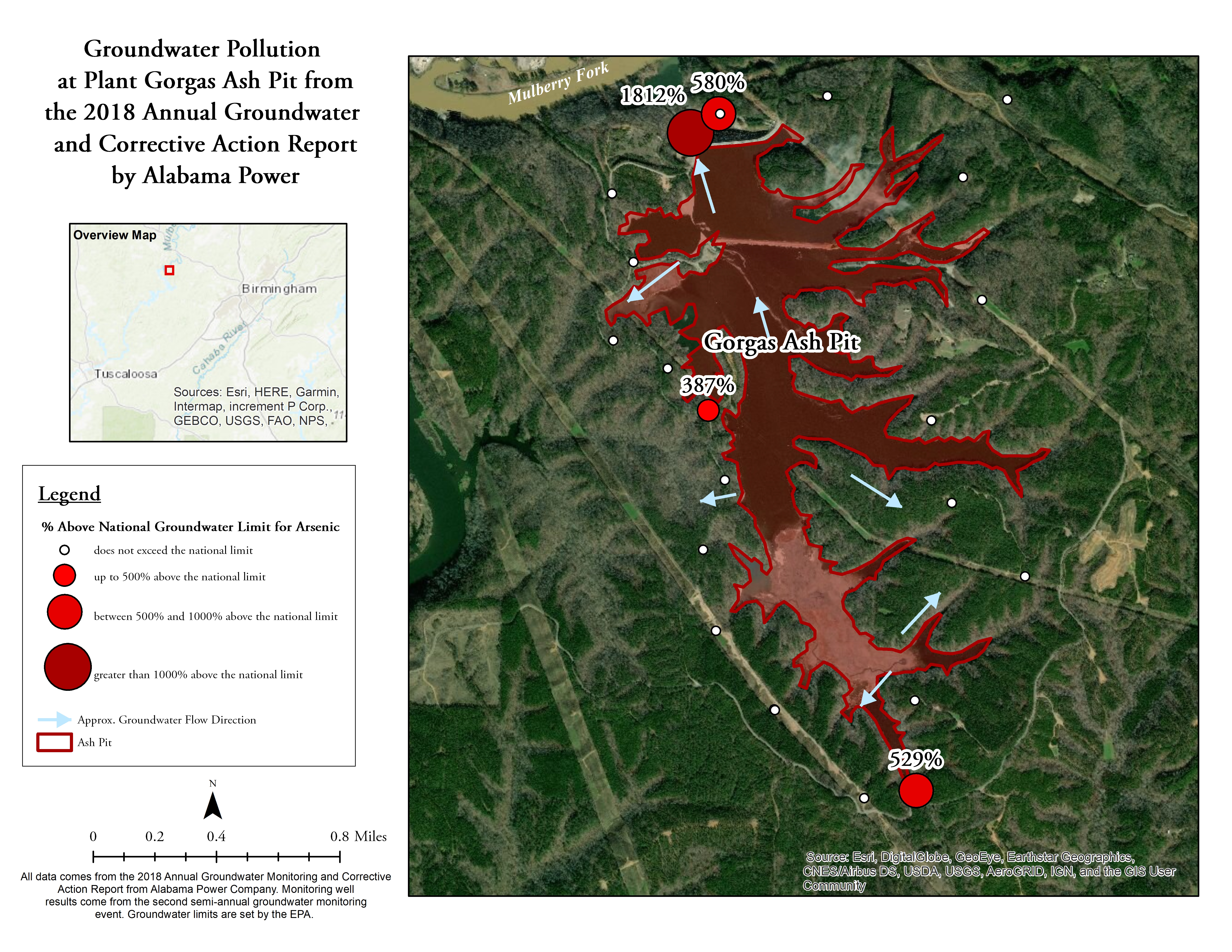
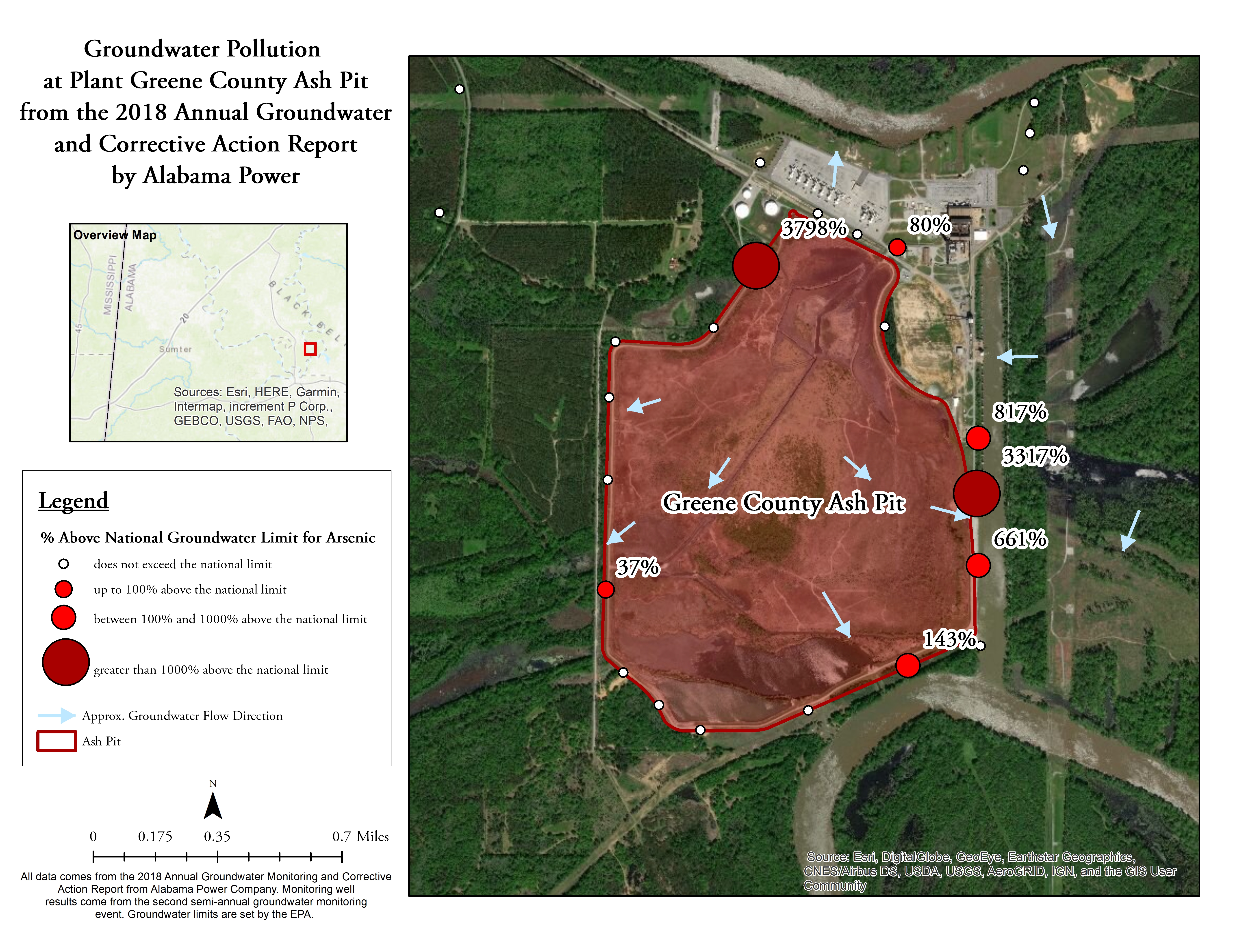
The environmental organizations – Alabama Rivers Alliance, Black Warrior Riverkeeper, Coosa Riverkeeper, and Mobile Baykeeper – developed these maps to show the threat coal ash poses to our groundwater, rivers, wildlife, economies, and health. Across the state, six coal ash pits are slated to be capped-in-place. Half of those (Plants Gorgas, Greene County, and Miller) are in the Black Warrior River basin. Cap-in-place covers the coal ash pit on top but still leaves it unlined on the bottom, allowing groundwater pollution to continue.
“Alabama Power’s own groundwater monitoring data shows we cannot leave coal ash waste from power plants in leaking, unlined pits next to our rivers,” said Nelson Brooke, Black Warrior Riverkeeper. “Groundwater monitoring by Alabama Power, Power South, and TVA shows toxic pollutants are leaking into groundwater from their nine unlined coal ash pits in Alabama.”
The maps come on the heels of a new report showing that Alabama Power’s only capped-in-place pit at Plant Gadsden is still leaking arsenic and radium into groundwater above national standards. Despite that fact, the utility plans to continue the use of this same flawed method at every unlined ash pit in the state. The Alabama Department of Environmental Management recently gave Alabama Power the maximum fine of $250,000 (less than 0.03% of the utility’s 2017 profit) for the Gadsden violations. Meanwhile, utilities across the southeast like Georgia Power, Duke Energy, Santee Cooper, Dominion Energy, and TVA are choosing to move nearly 250 million tons of coal ash at their plants to upland, lined landfills to protect citizens. Unlike these other utilities in the southeast, Alabama Power is still insisting upon leaving coal ash in vulnerable streams and wetlands where the pollution will continue to migrate into ground and surface water.
The data underlying these maps comes from Alabama Power and Power South’s own groundwater monitoring reports. The reports show that groundwater violations have occurred at every one of the six pits slated for closure. In the reports the utilities take samples from multiple wells along the edges of the ash pit. The samples at each well are then statistically manipulated to come up with a confidence interval (or range) of how much of a pollutant is in the groundwater at that site. Only when the upper and lower value for that range are above the regulatory limit is the utility determined to be in violation. These maps show the average value from that range only where both the lower and upper end of the range are above legal limits. These violations have resulted in $1,750,000 in fines for the utilities, but they have simply paid the fines and made no plans to stop the pollution.
At Plant Miller, monitoring well sample results show Alabama Power’s unlined coal ash pit leaked cobalt at 2.5 times the national groundwater limit. The Miller coal ash pit is also leaking arsenic and lithium in violation of national groundwater limits. At Plant Gorgas, monitoring well sample results show Alabama Power’s unlined coal ash lake leaked arsenic at 18 times the national groundwater limit. The Gorgas coal ash lake is also leaking lithium and molybdenum in violation of national groundwater limits. At Plant Greene County, monitoring well sample results show Alabama Power’s unlined coal ash pit leaked arsenic at 38 times the national groundwater limit. The Greene coal ash pit is also leaking cobalt and lithium in violation of national groundwater limits.
Groundwater monitoring data from unlined coal ash waste storage pits across Alabama clearly shows that pollutants are migrating into groundwater resources near rivers. Plant Gadsden’s ongoing groundwater contamination is occurring after Alabama Power used cap-in-place. The data underscores why power plants’ coal ash pit cannot be capped in place.
Background
Coal ash is the toxic waste that remains after coal is burned. It contains high concentrations of heavy metals, including mercury, arsenic, selenium, and chromium, which are hazardous to human health, wildlife, and waterways.
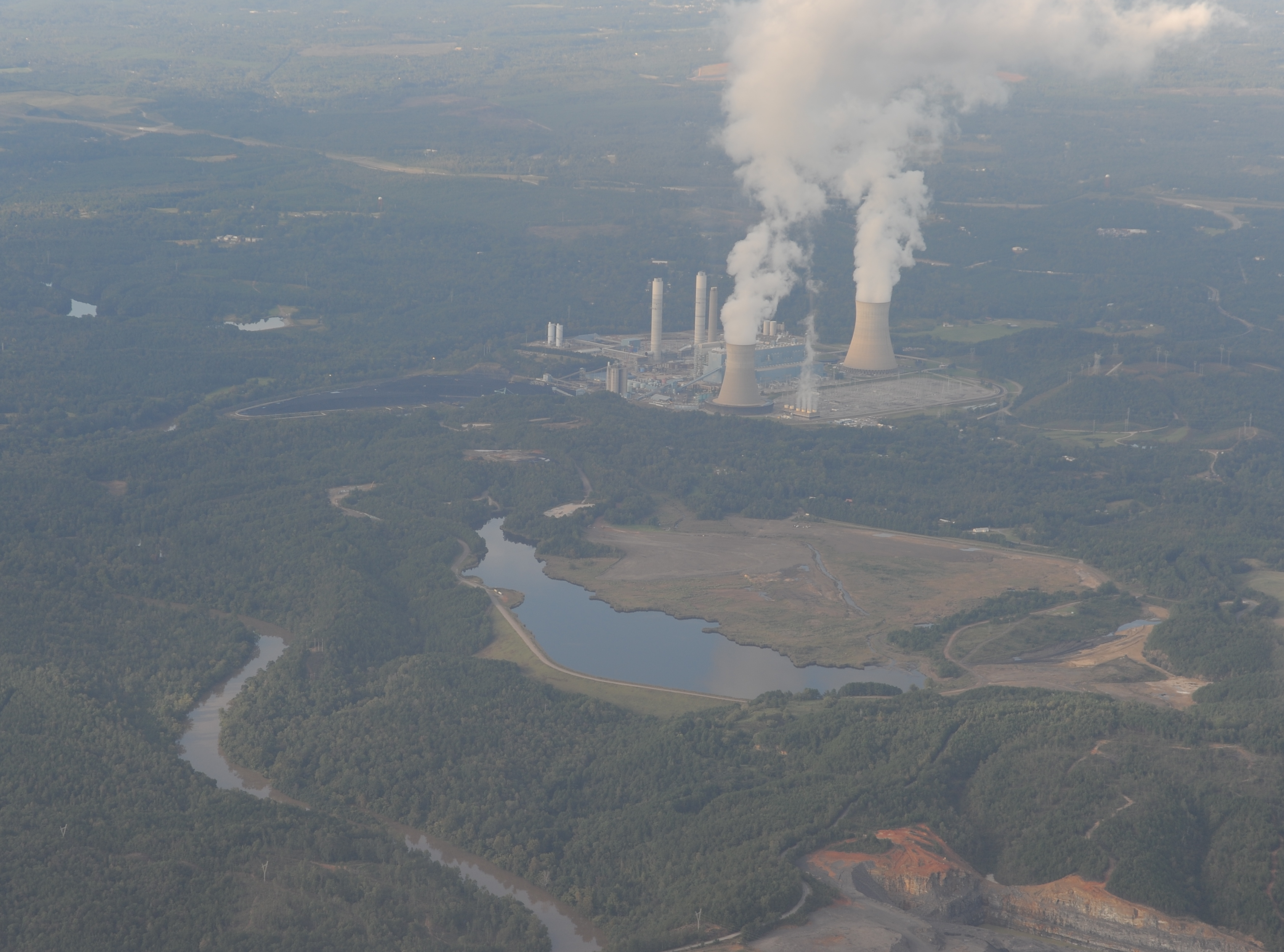
At Plant Miller, located on the banks of the Black Warrior River’s Locust Fork, more than 29 million tons of coal ash sits in a 321-acre unlined pit, behind an earthen dam approximately 170 feet tall. On average during 2018, the maximum daily discharge of coal ash wastewater from Miller’s ash pit into the Locust Fork of the Black Warrior River was approximately 11.51 million gallons. Alabama Power plans to begin de-watering the facility in 2019, with a final closure date estimated for 2029.
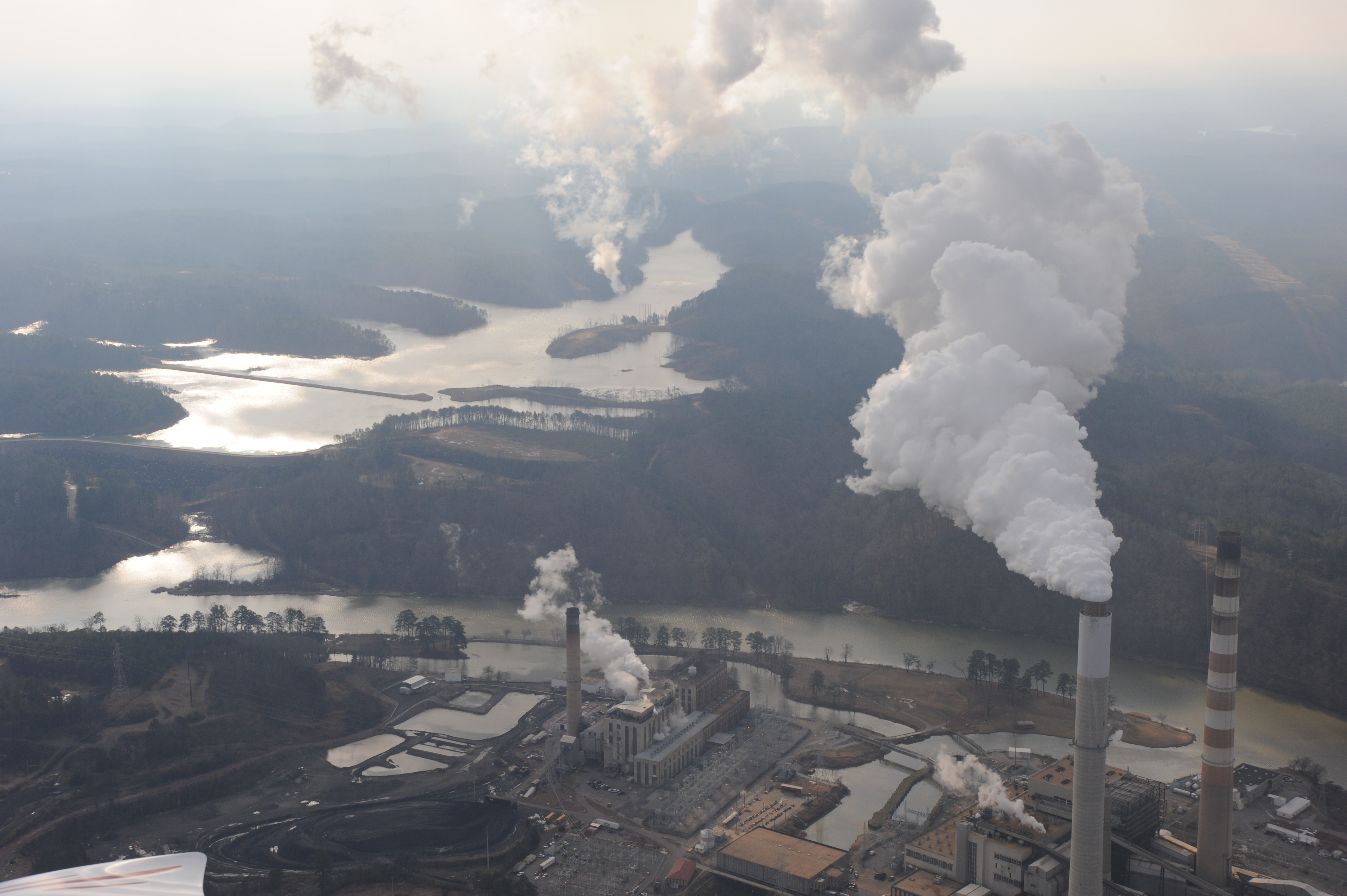
At Plant Gorgas, more than 40 million tons of coal ash has been dumped into Rattlesnake Lake, a 420-acre unlined impoundment formed by damming Rattlesnake Creek in 1953. On average during 2018, the maximum daily discharge of coal ash wastewater from Rattlesnake Lake into the Mulberry Fork of the Black Warrior River was approximately 28.49 million gallons. Alabama Power has announced its intent to begin closure of the Rattlesnake Lake coal ash dump in 2019, with final closure anticipated in 2028.
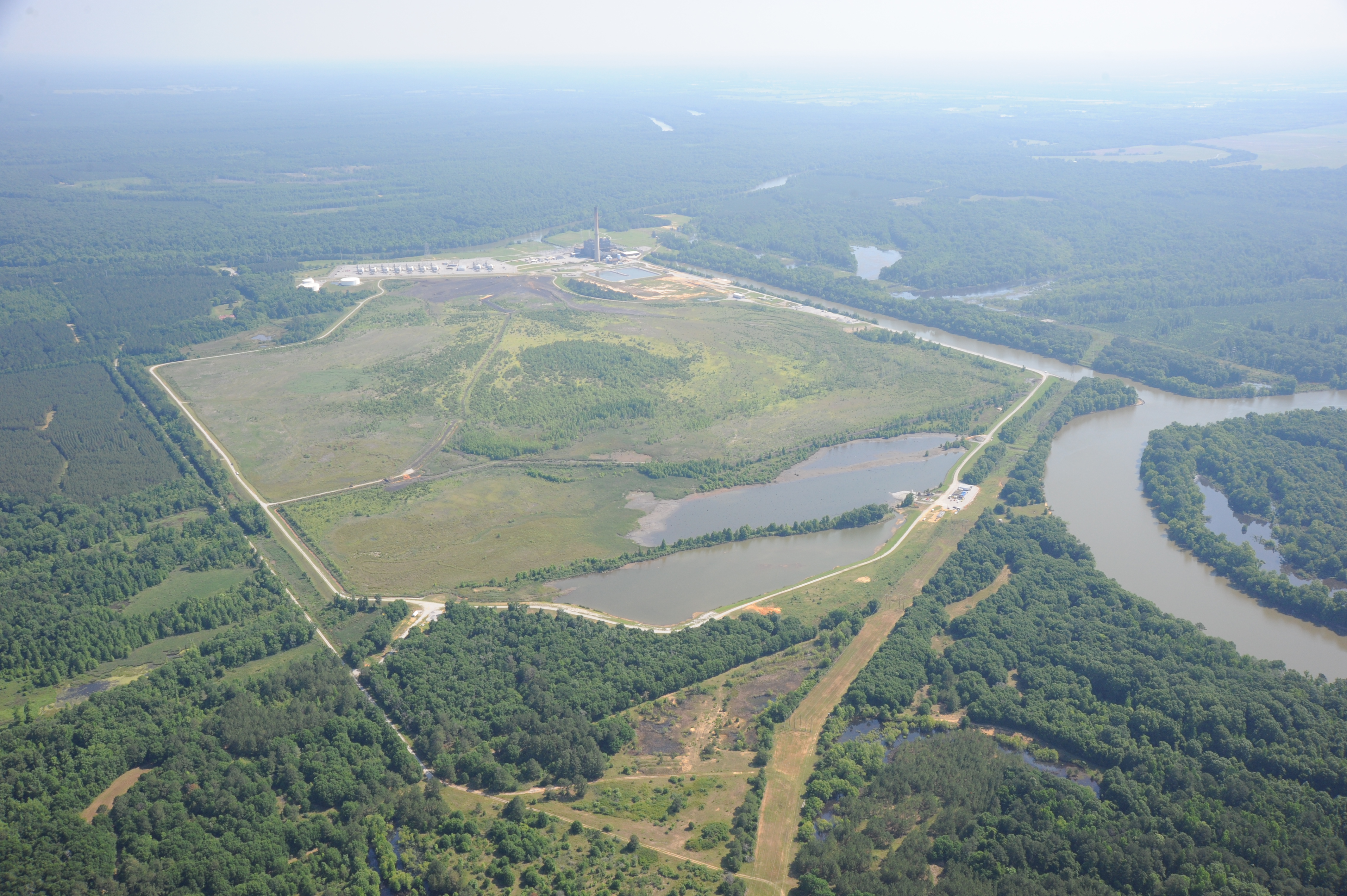
At Plant Greene County, more than 16 million tons of coal ash has been placed in a 489-acre unlined storage pit, located within a large bend on the Black Warrior River, on top of what once was Big Slough and associated wetlands, which fed into Backbone Creek, a tributary to the Black Warrior River. On average during 2018, the maximum daily discharge of coal ash wastewater from Greene County ash pit into the Black Warrior River was approximately 1.5 million gallons. Closure of the pit has already begun, with the facility initiating the de-watering process in April of 2019. Alabama Power anticipates that the cap-in-place procedure will be finished by 2024.
The coal ash waste sites at both Plants Miller (approximately 18 miles) and Gorgas (less than 15 miles) are upstream of the drinking water source for the City of Bessemer and the Warrior River Water Authority. Their drinking water intakes, as well as the intake for the Birmingham Water Works Board on the Mulberry Fork (which serves 200,000 customers) are within the potential inundation zone of a catastrophic breach of the dam at Plant Gorgas, meaning they would be covered in coal ash in the event of a failure of the dam at Rattlesnake Lake. Similar spills have already happened at coal ash pits in North Carolina and Tennessee.
In November 2016, to comply with federal regulations, Alabama Power announced its preliminary closure plans to “cap-in-place” the coal ash at Plants Miller, Gorgas, and Greene County. This decision contrasts with the decisions made by many other utilities in the southeast, which instead chose to excavate their coal ash and move it to lined landfills away from waterways.
Nelson Brooke took high-res pictures of Plants Miller, Gorgas, and Greene County on SouthWings flights.
To learn more about coal ash threats to Alabama, visit: https://blackwarriorriver.org/coal-ash-and-power-plants/
###
Black Warrior Riverkeeper’s mission is to protect and restore the Black Warrior River and its tributaries. The citizen-based nonprofit organization promotes clean water for improved public health, recreation, and wildlife habitat throughout the Black Warrior River watershed.

Click here to contact us!
Black Warrior Riverkeeper, Inc.
712 37th Street South, Birmingham, AL 35222
Phone: (205) 458-0095 Fax: (205) 458-0094
Copyright © 2001-2020 Black Warrior Riverkeeper Inc.
New Merkel helps good organizations do great things.


