


The Black Warrior River is named after Chief Tushkalusa, also the namesake of Tuscaloosa, Alabama. In Choctaw, tushka means warrior and lusa means black.
The Black Warrior River was a major hub of Mississippian culture, a.k.a. Moundbuilders, particularly at Moundville on a large bend of the river, where Moundville Archaeological Park is now located on the border of Hale and Tuscaloosa Counties. Eight hundred years ago, Moundville was the largest population center in North America. Learn more at https://moundville.museums.ua.edu/.
The Black Warrior River drains portions of seventeen counties in Alabama. The area the river drains, known as its watershed or basin, covers 6,276 square miles in Alabama and measures roughly 300 miles from top to bottom. The Black Warrior River watershed is home to over one million residents and contains 16,145.89 miles of mapped streams.
The Black Warrior River is formed by 3 beautiful headwater streams: Sipsey Fork, Mulberry Fork, and Locust Fork. Where the Mulberry and Locust forks merge West of Birmingham, the Black Warrior River proper forms the border of Jefferson and Walker counties. Near Tuscaloosa, the river flows out of the rocky Cumberland Plateau and through the Fall Line Hills before entering the sandy East Gulf Coastal Plain, forming the border of Greene and Hale counties in the Black Belt. This lower section of the river below Tuscaloosa still operates as a floodplain, with expansive riverbottom hardwood forests and thousands of acres of wetlands boasting bald cypress and water tupelo trees. Between Eutaw and Demopolis there are outcrops of white and gray chalk and clay bluffs from the Cretaceous Period along the river’s banks. At Demopolis the Black Warrior flows into the Tombigbee River, which flows downstream to Mobile Bay.
The Sipsey Fork, one of the Black Warrior’s three major tributaries (aka “Forks”) which was dammed to form Smith Lake, is federally designated as Alabama’s only Wild & Scenic River along its upper reaches, where its headwater originate within the 24,962-acre Sipsey Wilderness and Bankhead National Forest. The Sipsey Wilderness was designated by the Eastern Wilderness Areas Act of 1975 (12,000 acres), received an addition of 12,922 acres in 1988, and 40 acres in 2021. Thanks to advocacy by the Alabama Conservancy, this is the largest wilderness area in Alabama, and it was the first created East of the Mississippi River, sparking the eastern wilderness movement.
The Mulberry Fork is the most impacted of the three headwater forks of the Black Warrior River. Because of agricultural, municipal, and industrial pollution the Mulberry has a more polluted aquatic environment than the other Black Warrior forks.
The Locust Fork is the only headwater fork of the Black Warrior River that rises in a region other than the Cumberland Plateau, in a physiographic province known as Sand Mountain. According to Alabama geologist Jim Lacefield, the Locust flows through an ancient riverbed that is 300 million years old. Older than the Appalachian Mountains, this ancient riverbed cuts through mountains numerous times through features known as “water gaps.”
Jim Lacefield, author of Lost Worlds in Alabama Rocks: A Guide to the State’s Ancient Life and Landscapes, noted the following in 2021: “The Black Warrior Basin is renowned in the world of paleontology for its trace fossils, particularly of footprints of early reptiles and amphibians. A good summary of Coal Age life in Alabama can be found by Googling the term ‘Steven C. Minkin Paleozoic Footprint Site.’ Adding the word ‘images’ will show some of the extraordinary trace fossils that come in the past few decades from the Warrior Basin rocks.”
According to Eastern Fly Fishing Magazine, the National Park Service rated the Black Warrior’s three forks in the top 2% of U.S. streams for “outstandingly remarkable values.”
The Black Warrior River and its tributaries are a major source of drinking water for many cities including Birmingham, Bessemer, Cullman, Jasper, Oneonta, and Tuscaloosa.
The Black Warrior River watershed is home to 127 freshwater fish species (4 of which are federally listed as endangered), 36 species of mussels (5 of which are federally listed as endangered), 33 crayfish species, 15 turtle species (1 of which is federally listed as threatened), an endangered snail, an endangered salamander, and numerous other aquatic animals.
Alabama is ranked #1 in the United States for freshwater aquatic biodiversity, meaning we have more aquatic species of fish, turtles, crayfish, mussels, and snails than any other state. According to the Alabama Office of Water Resources, Alabama has more species of freshwater turtles than the rest of North America combined (52% of the continent’s species). According to the Alabama Department of Conservation and Natural Resources, Alabama is home to 97 species of crayfish, more than any other state.
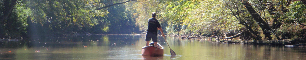
Boating magazine called the Black Warrior River one of America’s best kept secrets for recreational boating.
Alabama, “the River State,” contains more miles of navigable waterways than any other state. Over 200 miles of the Black Warrior Rive River system are navigable by barge – from Demopolis to North of Birmingham up the Mulberry and Locust forks. The Black Warrior is a busy commercial and industrial waterway for tugboats and their barges, which tow coal, chemicals, steel products, wood products, and more up and down the river for import and export. This is made possible due to 4 large lock and dam structures on the main stem of the river, built and maintained by the U.S. Army Corps of Engineers: Bankhead, Holt, Oliver, and Selden. Originally, in the 1800s the Corps built a network of 13 locks and dams along the Black Warrior, which were replaced and covered by higher water levels from the current 4.
Squaw Shoals is a 3 mile long rocky shoal between Birmingham and Tuscaloosa near the Tuscaloosa-Jefferson county line that was home to one of the largest stands of shoals spider lilies (Hymenocallis coronaria) in Alabama. Squaw Shoals was buried under water by the construction of locks and dams on the river. At the foot of the shoals, Lock 16’s construction began in 1909 and at Squaw Shoals, Lock 17’s construction began in 1910. Holt Lock was opened for navigation in 1966, replacing and flooding out the four locks upstream: Locks 14-17.
The 2 largest man-made lakes in the Black Warrior basin are 21,000 acre Smith Lake (Sipsey Fork) and 5,885 acre Lake Tuscaloosa (North River), both of which provide drinking water and recreational opportunities. Smith lake was built by Alabama Power in 1961 to provide cooling water for Gorgas Steam Plant on the Mulberry Fork, and later for Miller Steam Plant on the Locust Fork. Lake Tuscaloosa was built in 1970 to provide drinking water for the future of the surrounding area.
Most of Alabama’s coal reserves are found in the Warrior Coal Field, which is the source of so much coal mining in the Black Warrior basin over the past 200 years. There are over 50 currently permitted surface or strip mines, mountaintop removal mines, and underground mines. Strip mines can range up to nearly ten thousand acres in size and some of the deepest vertical shaft underground coal mines in America are in Tuscaloosa County. Most of the coal mined here is exported overseas. Coalbed methane hydraulic fracturing occurs at thousands of wells to extract natural gas trapped in coal deposits.
When Black Warrior Riverkeeper was founded the protect the Black Warrior River in 2001, we were the 72nd autonomous chapter of Waterkeeper Alliance. Now there are over 350 Waterkeeper organizations on 6 continents working to protect their local sources of clean water.